Category:Struell Wells
Jump to navigation
Jump to search
wells in County Down ,_October_2009.JPG) ,_October_2009.JPG) ,_October_2009.JPG) | |||||
| Upload media | |||||
| Instance of | |||||
|---|---|---|---|---|---|
| Location |
| ||||
 | |||||
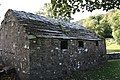
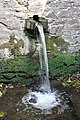
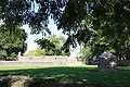
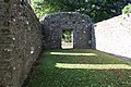
English: Struell Wells is a set of four holy wells 1.5 miles (2.4km) east of Downpatrick, County Down, Northern Ireland (grid ref: J513442).
Media in category "Struell Wells"
The following 24 files are in this category, out of 24 total.
-
 Struell Wells (01), October 2009.JPG 4,272 × 2,848; 4.39 MB
-
 Struell Wells (02), October 2009.JPG 4,272 × 2,848; 7.84 MB
-
 Struell Wells (03), October 2009.JPG 4,272 × 2,848; 4.21 MB
-
 Struell Wells (04), October 2009.JPG 2,848 × 4,272; 7.97 MB
-
 Struell Wells (05), October 2009.JPG 4,272 × 2,848; 7.36 MB
-
 Struell Wells (06), October 2009.JPG 4,272 × 2,848; 6.75 MB
-
 Struell Wells (07), October 2009.JPG 4,272 × 2,848; 4.5 MB
-
 Struell Wells (08), October 2009.JPG 2,848 × 4,272; 8.37 MB
-
 Struell Wells (09), October 2009.JPG 2,848 × 4,272; 7.73 MB
-
 Struell Wells (10), October 2009.JPG 2,848 × 4,272; 6.61 MB
-
 Struell Wells (11), October 2009.JPG 4,272 × 2,848; 5.09 MB
-
 Struell Wells (12), October 2009.JPG 4,272 × 2,848; 7.66 MB
-
 Struell Wells (13), October 2009.JPG 4,272 × 2,848; 6.95 MB
-
 Struell Wells (14), October 2009.JPG 4,272 × 2,848; 7.64 MB
-
 Struell Wells (15), October 2009.JPG 4,272 × 2,848; 8.26 MB
-
 Struell Wells (16), October 2009.JPG 2,848 × 4,272; 5.47 MB
-
 Struell Wells (17), October 2009.JPG 2,848 × 4,272; 7.54 MB
-
 Struell Wells (18), October 2009.JPG 4,272 × 2,848; 7.75 MB
-
 Struell Wells (19), October 2009.JPG 4,272 × 2,848; 7.03 MB
-
 Struell Wells (20), October 2009.JPG 4,272 × 2,848; 8.38 MB
-
 Struell Wells (21), October 2009.JPG 4,272 × 2,848; 4.73 MB
-
 Struell Wells (23), October 2009.JPG 2,848 × 4,272; 4.59 MB
-
 Struell Wells (24), October 2009.JPG 4,272 × 2,848; 3.58 MB
-
 Struell Wells County Down.jpg 1,482 × 1,015; 1.06 MB
,_October_2009.JPG)
,_October_2009.JPG)
,_October_2009.JPG)
,_October_2009.JPG)
,_October_2009.JPG)
,_October_2009.JPG)
,_October_2009.JPG)
,_October_2009.JPG)
,_October_2009.JPG)
,_October_2009.JPG)
,_October_2009.JPG)
,_October_2009.JPG)
,_October_2009.JPG)
,_October_2009.JPG)
,_October_2009.JPG)
,_October_2009.JPG)
,_October_2009.JPG)
,_October_2009.JPG)
,_October_2009.JPG)
,_October_2009.JPG)
